
by Michael Landers | Jun 4, 2021 | Drone Mapping, Innovation
RE: General Assembly of PA – HOUSE BILL No. 609 DATE: May 24, 2021 BY: J. Todd Henwood, PLS It has come to my attention that there is a growing concern from my GIS and drone mapping colleagues in the mapping industry regarding Pennsylvania House Bill No. 609....
by Michael Landers | Apr 19, 2021 | 3D Modeling, Digital Twin, Drone Solutions, Webinars and Workshops
Available OnDemand In a recent webinar with Virtuosity, a Bentley Company, Eye-bot discusses the advantages of drone photogrammetry over conventional surveying. Dakota Campbell, the Geospatial Analyst at Eye-bot Aerial Solutions, presented how Eye-bot successfully...

by Michael Landers | Apr 6, 2021 | Digital Twin, Drone Solutions, Innovation
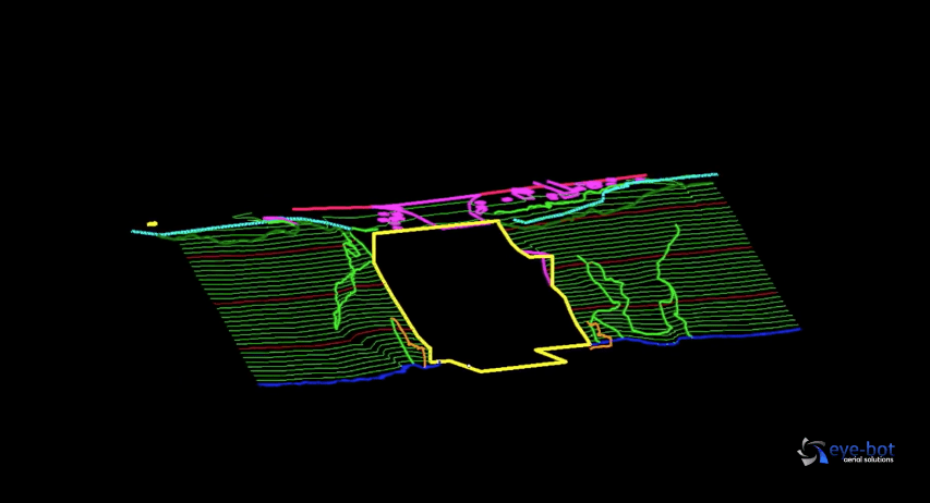
PROJECT OVERVIEW It can be argued that compliance either drives or hinders technological advancement. In this case study, Eye-Bot Aerial Solutions (Eye-Bot) demonstrates how the use of technology and survey-grade data deliverables provided NewFields, an...

by Michael Landers | Mar 19, 2021 | 3D Modeling, Construction & Infrastructure, Digital Twin, Innovation
Project Intro It is no secret that slopes fail. Whether it is along a roadway, overtop a pipeline, on the side of a well pad, or, in this case study, adjacent to a water intake structure along a river, slopes fail and need to be stabilized. The geotechnical...

by Michael Landers | Mar 6, 2021 | Innovation, Webinars and Workshops
In this webinar, you will learn how you can generate new value for your organization with specialized data capture and visualization tools. Register for March 24 Webinar VEERUM and Eye-bot have prepared a joint solution to accelerate digital adoption in the energy...